I will add a general entry to the database for the Yellowbush Creek site (Structure 2259). Hopefully discrete structures can be identified there if work is conducted in the future. The work described by Keener et al. (2010) was carried out by PAST. I thank Craig Keener for pointing out the publication on the Ohio Archaeological Council webpage.
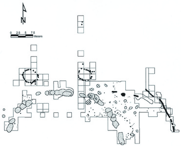
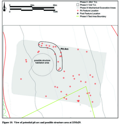
A 2010 report by Craig Keener, Kevin Nye, and Joshua Niedermeir (available here) describes excavations at the Yellowbush Creek site (33Ms29), a Late Archaic site in Meigs County, Ohio, dating to the second millennium BC. Geophysical data collected during Phase II suggested "possible post formations indicative of structures," specifically "circular or arc shaped anomaly patterns" (Keener et al. 2010:5, 15). Phase II excavations identified a cluster of posts and pit features that suggested the presence of some kind of structure (Keener et al. 2010:15). Phase III investigations exposed an arc of pits around an open area that was suggestive of a structure location (illustration to right, from Keener et al. 2010:16).
I will add a general entry to the database for the Yellowbush Creek site (Structure 2259). Hopefully discrete structures can be identified there if work is conducted in the future. The work described by Keener et al. (2010) was carried out by PAST. I thank Craig Keener for pointing out the publication on the Ohio Archaeological Council webpage.
0 Comments
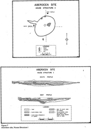
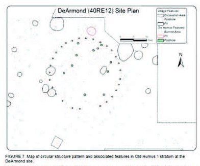
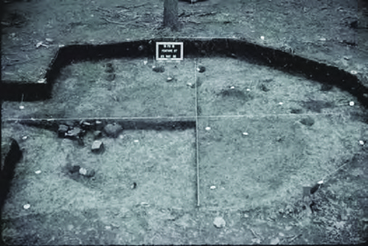
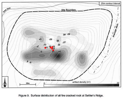
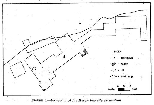
"Open" structures (i.e., structures that do not enclose a discrete area) were built and used throughout much of prehistory in eastern North America. A 2009 paper in North American Archaeologist by Craig Keener, Kevin Nye, and Joshua Niedermier describes a possible Early Woodland "open" structure at the Settler's Ridge site (33-As-32) in Ashland County, Ohio. Keener et al. (2009:43) suggest that a cluster of posts (highlighted in red in the illustration to the right, modified from Keener et al. 2009:45) may "represent some kind of lean-to, wind break, or partial enclosure" in the central portion of the site. The deposits at Settler's Ridge date to the first millennium BC and are associated with the Leimbach Phase. Work at the Settler's Ridge site was performed by Professional Archaeological Services Team, a CRM firm based in Plain City, Ohio. The structure will be Structure 2258 in the database. I grew up very near where this site is located. A word of advice: watch your speed heading into Jeromesville on US 250. James Wright's (1967) report on the Laurel Tradition describes the remains of a probable structure from the Heron Bay site (DdIn-1) in the Thunder Bay District of Ontario. Again, I thank Chris Ellis for checking my "Most Wanted" list and sending me the relevant pages from the report. As described by Wright (1967:5, 8) and shown in the figure to the right, the northeastern portion of the area excavated at Heron Bay contained "a clustering of twenty-five post moulds which may represent a house structure." The posts appear to represent the remains of a circular/elliptical structure that may have been about 3 m in diameter. Wright (1967:8) stated that recreating a house from the posts would be an "exercise in fantasy." Although Wright (1967:8) dismissed the results of a radiocarbon determination (GSC-208) from the site as "unacceptable," the age estimate of about AD 610 is within the age range of what is now accepted as associated with Laurel (see the references listed in the Canadian Archaeological Association's discussion of the C14 date). The structural remains from Heron Bay will be included as Structure 2257 in the database. James Wright's (1972) manuscript on the Shield Archaic contains a brief description and illustrations of a semi-subterranean structure from the Aberdeen site (AL-7). The figure to the right is taken from Wright (1972:54). The structure measured about 4.3 m by 3.1 m and had "an entrance way 6 ft in length, a central pit, a hearth, several surviving tent-weighting stones, what is interpreted as a sleeping platform, and a definite concentration of artifacts and debris within the eastern confines of the house" (Wright 1972:55). A radiocarbon determination (S-506) dates the structure to about 1075 BC. I thank Chris Ellis for looking at my "Most Wanted" list and taking the time to scan and send me the portion of Wright's paper that described the structure from Aberdeen. A second structure was documented at Aberdeen, and is presumably described in Wright's separate report of the Aberdeen excavations (which I will now add to my list of things to track down). I don't yet have a map showing the location of the site. I believe (please correct me if I'm wrong - I will confirm/clarify details of the site's location when I get a copy of the full report) the Aberdeen site is located in what is now the Kivalliq Region of Nunavut, on the Thelon River, presumably near Aberdeen Lake. At the time of Wright's work at Aberdeen, the region was known as the Keewatin District. Although this is pretty far afield from the Eastern Woodlands, I think it is useful to include information on sites like these for comparative purposes. I'm not currently maintaining a map of Nunavut (or Manitoba), but I might add one depending on how the database grows. House Structure 1 from Aberdeen will be Structure 2256 in the database. In a 2010 paper (available here and here and here), Lynne Sullivan and Shannon Koerner describe a circular post structure at the DeArmond Site (40-Re-12), Roane County, Tennessee. WPA excavations at the site produced features, debris, and architectural remains, much of which was attributable to Mississippian occupations. Sullivan and Koerner argue that the single circular structure from the site (Feature 30) predates the Mississippian occupation and is Late Woodland in age. As shown in the illustration to the right (from Sullivan and Koerner 2010:39), the structure was of single post construction and measured approximately 8.2 m in diameter. The structure will be added to the database as Structure 2255. I thank Dr. Sullivan for bringing the paper to my attention. A 2004 paper by Dennis Curry and Maureen Kavanagh (available online here) describes excavations at the Rosenstock Village site (18-Fr-18) in Frederick County, Maryland. The main deposits at the site are associated with the Late Woodland Montgomery Complex, dating to the fourteenth century AD. Again I thank Dr. Dennis Curry for bringing the site and report to my attention. Two "keyhole" structures (Features 2 and 27) were identifed. Feature 27 is shown in the illustration to the right (from Curry and Kavanagh 2004:14, Figure 19). At the Rosenstock site, these small (< 5 square meters) elliptical, semi-subterranean structures were interpreted as the probable remains of sweat lodges. While similar structures have been interpreted as sweat lodges at other sites, there has been some debate about whether "keyhole" structures may be the remains of houses or storage features (see MacDonald 2008; Smith 1976). The two structures from Rosenstock will be added to the database as Structures 2253 and 2254. Excavations in 2002 and 2003 exposed two domestic post structures at the Winslow Site (18-Mo-9) in Montgomery County, Maryland. These structures are described in a 2005 report by Richard Dent in Maryland Archaeology. I thank Dr. Dennis Curry for making me aware of the structures and sending me a copy of the paper. The outlines of both structures can be seen in the illustration to the right (Figure 5 from Dent 2005:11). Various features and segments of a palisade were also exposed. The structures were attributed to the Montgomery Complex and believed to date to the mid-fourteenth century AD. They will be added to the database as Structures 2251 and 2252. |
AuthorAndrew A. White Archives
January 2016
Categories
All
|