Eastern Woodlands Household Archaeology Data Project
  • Home
  • About
  • What's New
  • Structures by State/Province
    • Alabama
    • Arkansas
    • Connecticut
    • Delaware
    • Florida
    • Georgia
    • Illinois
    • Indiana
    • Iowa
    • Kentucky
    • Louisiana
    • Maine
    • Maryland
    • Massachusetts
    • Michigan
    • Minnesota
    • Mississippi
    • Missouri
    • New Hampshire
    • New Jersey
    • New York
    • North Carolina
    • Ohio
    • Pennsylvania
    • Rhode Island
    • South Carolina
    • Tennessee
    • Vermont
    • Virginia
    • West Virginia
    • Wisconsin
    • Ontario
    • New Brunswick
    • Nova Scotia and PEI
    • Quebec
  • Database
    • April 2015 (DINAA link test)
    • March 2014
    • February 2014
  • Bibliography
    • Full Bibliography
    • Publications Online
  • More . . .

Late Woodland Structures from the Wood Site, Nelson County, Virginia

3/29/2014

0 Comments

 
Picture
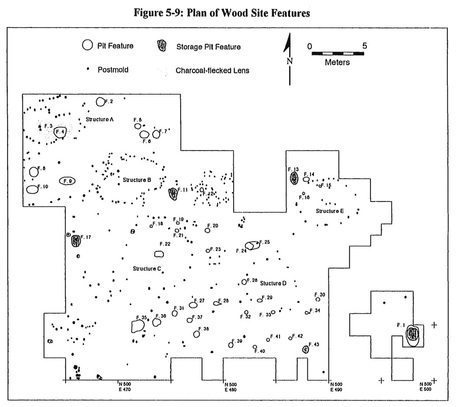
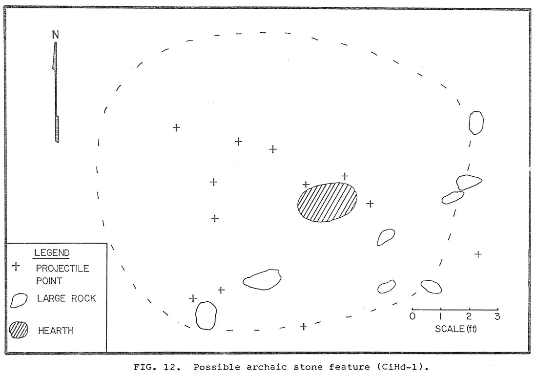
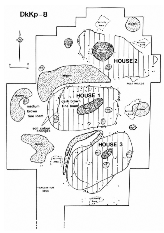
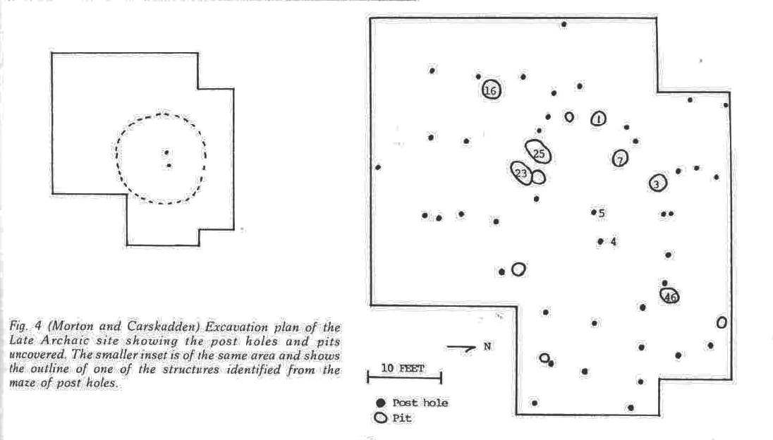
Martin Gallivan's (1999) dissertation includes information on several Woodland and Late Prehistoric sites in Virginia with structural remains (see also his later paper in American Antiquity).  The figure to the right (from Gallivan 1999:197) shows the distribution of postmolds and features exposed in excavations at the Wood site (44-Ne-143), Nelson County.  Gallivan used multiple approaches to analyze the distribution of posts, identifying the outlines of five elliptical structures (Structures A, B, C, D, and E) of varying size.  Radiocarbon dates from features at the site suggest the structures were constructed around AD 1000-1050.  The Wood site structures will be Structures 2237-2241 in the database.

0 Comments

Selkirk Structures from the Spruce Point site, Western Ontario

3/28/2014

0 Comments

 
Grace Rajnovich's (1983) thesis describes excavation of two Selkirk (Late Woodland) habitation structures at the Spruce Point site (DjKq-1) in the Kenora District of western Ontario.  The structures were defined by a color and texture contrast between the interior and exterior sediments.  Both had interior features.  Neither structure was completely exposed.  Rajnovich provided inferred outlines of the structures.  She estimated their dimensions to have been about 4m in width x 6 or 7m in length.  The plan view of Structure A is shown to the right.  The plan view of Structure B is here.
Picture
Above: Structure A (from Figure 8 of Rajnovich 1983:98).  This will be Structure 2235 in the database.
0 Comments

Middle Woodland Structure from the Hardin Bridge Site, Bartow County, Georgia

3/28/2014

0 Comments

 
Picture
A 2008 report prepared by New South Associates (edited by R. Jeannine Windham, Christopher Espenshade, and Julie Coco) details excavations and analysis of materials associated with the remains of Middle Woodland household at the Hardin Bridge site (9-Br-34) in northwest Georgia.  The report is available on Chris Espenshade's Academia.edu page.

The preserved architectural features at the site did not allow the unambiguous definition of the outlines of a single structure.  Based on artifact analysis, the authors interpret the Middle Woodland remains at the site to be the product of single household that would have occupied a single residential structure.  That structure was likely an oval or rounded rectangular structure measuring about 9m in width and 11m or 20m in length (Windham et al. 2008). The illustration above (Figure 11.1 from Windham et al. 2008:423) shows the outline of a structure with larger dimensions in blue and the most likely candidate for a smaller structure outlined in pink.  The Hardin Bridge structure will be added to the database as Structure 2234.


0 Comments

Two Archaic Structures from Ontario

3/25/2014

0 Comments

 
Continuing the Ontario theme . . .

Ash Rapids East

A
1988 paper by C. S. "Paddy" Reid contains illustrations of several prehistoric structures.  One of those is this structure from the Ash Rapids East site (DjKq-4, Kenora District) identified as an Archaic house.  The focus of the paper (Reid 1988) is largely methodological, and few details are provided about the structures.  This structure appears to have been a shallow basin, defined by the contrast between the basin fill and the surrounding matrix.  No information is given on how the structure was dated (the only entry for the Ash Rapids East site I could find in the Canadian Archaeological Radiocarbon Database pertained to a much later Blackduck occupation). A quick search online did not produce any later papers or reports that discuss this structure, but that doesn't mean they don't exist.  If you have more information about this structure, please let me know. I estimate the size of the structure to be about 3.5 x 4m based on the plan map.

Smoothwater Lake

The second Ontario Archaic structure of the day is a possible "tent ring" from the Smoothwater Lake site (CiHd-1) in the Timiskaming District.  The possible structure is described in John Pollock's (1975) M.A. thesis (available online here):

     "Certainly intriguing but hypothetical is a feature of large spaced rocks that may represent a tent ring (Fig. 12).  The large rocks that comprise the ring were plotted on the upper 3-inch level and thence removed, even though several extended into the second 3-inch level.  In hypothesizing this feature, data from all levels were considered and three main criteria were used in reconstructing it.  The rocks are all over 5 inches in diameter, a central hearth is present, and eleven of the seventeen projectile points excavated were concentrated within the rock feature at CiHd-1. These points all pertain to the late Shield Archaic period" (Pollock 1975:51,56).

Pollack (1975:178) estimates the footprint of the structure to have been about 10' x 12' (~ 3.0 x 3.7m).
Picture
Above: Figure 9 from Reid (1988:211).  This will be Structure 2232 in the database.
Picture
Above: Figure 12 from Pollock (1975:55). This will be Structure 2233 in the database.
0 Comments

Citation of the Database, "Most Wanted" Publications, FAQ

3/24/2014

0 Comments

 
Citation

Although the database is still early in its development, the "how do you cite it?" question has already popped up.  I did a little poking around online and found a few examples of database citations.  None seemed to exactly fit the EWHADP situation, however, as they referred to databases of material (i.e, articles) that already had separate citations.  I came up a general format for a "suggested citation" following this example:

White, Andrew A., and Benjamin Steere.  EWHADP Database 2014_03_12.  Eastern Woodlands Household Archaeology Data Project, 12 March 2014.  Web (www.householdarchaeology.org).  Accessed [day] [month] [year].

Ben Steere agreed to be co-author because of the volume of previously-compiled data that he contributed to the database. 

I may change the format of the suggested citation based on advice I get from others.  I like this format, however, because it clearly identifies which "issue" of the database is being cited.  This is useful because the database will continue to grow and the information associated with each listing may change from one version to the next.  It will be important to (1)
be able to specify which version was consulted and (2) keep those older versions available.

"Most Wanted"

I have added a Most Wanted section to list publications that I would like to have a look at because they reportedly contain data on structures that I would like to include in the database.  As you might guess, many of these will be contract reports that may be impossible to get through ILL or other conventional means.  I'm hoping that those of you interested in this project will check this page from time to time to see if you have any of the "most wanted" publications either on your bookshelf or (better yet) in an electronic format on your computer.  Please remember that I'm interested in providing open access to information, not documents, through this site.  Many of the "gray literature" publications that contain primary data on structures also contain information (such as precise site locations) that should not be openly distributed.  Protecting site locations is my main rationale for using the center of a county as a site's "location" for purposes of plotting in GIS.

FAQ

I have added a Frequently Asked Questions (FAQ) page.  Currently, this page contains only two questions:
  • How do I cite the database?
  • What if I have information to contribute?
In answer to the second question, I have added a contact form to the site. Email also always works:  aawhite@umich.edu.
0 Comments

Woodland Structures from the Ballynacree Site, Kenora District, Ontario

3/22/2014

0 Comments

 
I stumbled upon a paper by Reid and Rajnovich (1991) that describes three Woodland structures from the Ballynacree site in the Kenora District of western Ontario.  The structures are about 8m x 4m, defined by both postmolds and contrasts between interior and exterior sediments.  At the time the paper was written, the three structures from the site constituted the majority of known, excavated Laurel houses.  I do not know if that is still the case.

Three radiocarbon determinations suggest that House 1 dates to about AD 1250. This is, of course, a relatively late age for something that is called "Middle Woodland."  These houses, like others that strain the Midwest/Southeast-centered cultural-historical framework that I'm currently using, are encouraging me to rethink the organization of the database.  Since the relationships between our temporal and cultural chronologies are not consistent across the eastern woodlands, it may be a good move to separate them in the organization of the database. I'm considering simply dividing "time" into discrete blocks (say 200, 500, or 1000 years in duration) and then several columns to categorize the cultural-historical placement of the site (e.g., Archaic - Late Archaic - Brewerton).  This would allow one to plot groups of contemporaneous structures within thicker or thinner slices of time.  Something to think about.
Picture
Above:  Figure 3 from Reid and Rajnovich 1991:196.  The caption is "The Ballynacree site excavations revealed three houses with their associated features--a complete Laurel village.
The Reid and Rajnovich (1991) paper contains pointers to publications with data on several Woodland and Archaic structures in the region.  I've never been there, but based on its entry in Large Canadian Roadside Attractions it looks like a nice place to visit.
0 Comments

Late Archaic Post Structure(s) from 33-Mu-29, Muskingum County, Ohio

3/21/2014

0 Comments

 
A 1975 paper by James Morton and Jeff Carskadden in Ohio Archaeologist describes the remains of one or more post structures from a site in Muskingum County, Ohio (Morton and Carskadden 1975).  The outlines of the structure(s) represented by the posts are not particularly clear.  The authors suggest that some of the posts may belong to a circular or semi-circular structure with two central posts (see illustrations below from Carskadden and Morton 1975).  The posts could also mark the location of a large, open structure or several smaller arc-shaped structures.

Neither a name or a number is given for the site in the original paper.  I found the site number 33-Mu-29 associated with the radiocarbon date (I-7604) discussed in the paper in the Kentucky, Ohio, and West Virginia Radiocarbon Database maintained by Cultural Resource Analysts. 
Picture
0 Comments

DINAA Presentation

3/20/2014

1 Comment

 
Today I gave a short presentation on the EWHADP to the DINAA (Digital Index of North American Archaeology) workshop that is taking place at the University of Tennessee.  I couldn't go in person, so I missed being able to meet the participants face-to-face. I also missed out on the sandwich and salad bar lunch, which, according to the workshop agenda, included "your choice of a brownie or a cookie + two gallons of extra coffee."  That sounds about right.  Anyway, I think the presentation went well and I hope that we can figure out how to made the EWHADP data accessible through the DINAA database and vice versa.  That could be pretty sweet. The presentation is here (small version without animations).
Picture
1 Comment

Middle-Late Woodland Structures from Zencor Village, Franklin County, Ohio

3/18/2014

0 Comments

 
Daniel Zulandt's M.A. thesis (Zulandt 2010 - available online here) contains plan maps of the 1957 and 1958 excavations at the Zencor Village site (33-Fr-8) in Franklin County, Ohio.  Those excavations exposed the remains of at least three post structures dating to somewhere in the period A.D. 500-1000.  Raymond Baby and colleagues mentioned the existence of these structures in several short papers (e.g., Baby 1971; Baby and Shaffer 1957; Mays and Baby 1958), but with scant details:

"The remains of at least three houses . . . The structures represented by the postmolds were 25 to 36 feet in diameter, with an overlapping wall serving as an entrance.  The postmolds averaged 0.6 feet in diameter and were set in the ground 1.5 feet deep and 2.5 feet apart"
(Baby 1971:196).

The plan maps reproduced by Zulandt (2010:Figures 5, 6, and 7) show the post structures and their relationships to features at the site.  I don't know that these maps were not available elsewhere prior to Zulandt's thesis, but this is the first place I have seen them and I think it is useful to point out their existence. 

I already had an entry for the Zencor Village site in the database.  In the next issues of the database, however, there will be one entry for each structure.  The dimensions of each structure will be estimated from these drawings.
Picture
Figure 7 from Daniel Zulandt's thesis (Zulandt 2010:25), showing remains of structure in Area A' (this will be Structure 2227 in the database).
Picture
Figure 6 from Daniel Zulandt's thesis (Zulandt 2010:24) showing remains of structures in Area B (Structure 670 in the database) and Trench 1 (Structure 2212 in the database).
0 Comments

Digital Index of North American Archaeology

3/17/2014

0 Comments

 
I've been invited to give a short presentation on the EWHADP for the DINAA (Digital Index of North American Archaeology) workshop that will be going on at the University of Tennessee this week.  DINAA is operating through Open Context, which is a web-based, open access initiative that "reviews, edits, and publishes archaeological research data."  It is possible that this site and the information it contains will eventually be linked to DINAA in some way or another.  There could be several advantages to such a linkage.  The most obvious one, of course, would be a general increase in the ease of access to information for everyone.  Open access is good. Period.

I'm not yet sure exactly what I'm going to talk about. Since the site is new, I will probably focus on my motivations for creating it and what I hope it accomplishes. 
I will be able to give my opinions on the downside of the regionalization of research data and agendas and the upside of blurring the lines between regions by linking smaller scale datasets into larger ones.  Whatever the specific content of my DINAA presentation, it will be a relief to talk for an entire 15 minutes without attempting to describe complex systems theory.  Also, since it will be via Skype, I can wear slippers and be almost certain that I won't miss my connecting flight.
Picture
I produced the map above for my presentation.  It shows the current number of listings in the database by state/province.  The large numbers of structures at many Mississippian settlements produce the high counts in Illinois and several states in the Southeast (figure to right).  The dataset is weakest all along the Atlantic coast and on the western side of the Mississippi River. 

It would be interesting to know to what degree we can attribute the absence of database listings to (1) the absence of structures and/or (2) the absence of excavated structures.  In other words, does the absence of structures in the database reflect a real absence of structures or, alternatively, simply the absence of information about those structures? 

The EWHADP will not be able to answer that question by itself.  First, it is far too early in development of the database to know if a lack of reported structures from an area means that structures have not been identified there.  There are a lot more data to be entered and a lot more tree shaking to be done before we can really see where there are spatial gaps.  Second, because the EWHADP is only concerned with positive evidence (i.e., sites with structures present), it cannot answer questions about negative evidence (i.e., sites with no structures present).  Linking to efforts like DINAA will be required to allow one to confidently discriminate between the absence of evidence and evidence of absence.  Such a linking will also allow the spatial distribution of structures to be systematically examined in relation to the spatial distribution of other kinds of archaeological remains.  Sounds like a winner to me. 
Picture
Picture
0 Comments
<<Previous
Forward>>

    Author

    Andrew A. White
    aawhite@mailbox.sc.edu

    Archives

    January 2016
    September 2015
    May 2015
    April 2015
    January 2015
    October 2014
    August 2014
    July 2014
    May 2014
    March 2014
    February 2014

    Categories

    All
    Crowdfunding
    DINAA
    Early Woodland
    Florida
    Georgia
    Illinois
    Late Archaic
    Late Woodland
    Maryland
    Michigan
    Middle Archaic
    Middle Woodland
    Mississippian
    Nunavut
    Ohio
    Ontario
    Tennessee
    Virginia

    RSS Feed

    Enter your email address to receive updates to this section of the EWHADP:

    Delivered by FeedBurner

Powered by Create your own unique website with customizable templates.